

Planetary Resources plans to put mass produced 20 kilogram space telescopes into low earth orbit starting at the end of 2013 Some have criticized Planetary Resources as something that will lose a lot of money. I contend that it will be highly profitable even before they mine anything.
It will use laser communication to transmit information back. The lens look like an 9 inch (22 centimeter) diameter telescope.
It uses star cameras for orientation
It uses reaction wheels to point itself. Use that basic stability and enhance it to subarc second pointing.
They can point to the earth and get 2 meter resolution of the ground.
Planetary Resources can choose to make themselves very profitable before any material is mined. Satellite imaging, space telescopes and space data sales are markets that will work.
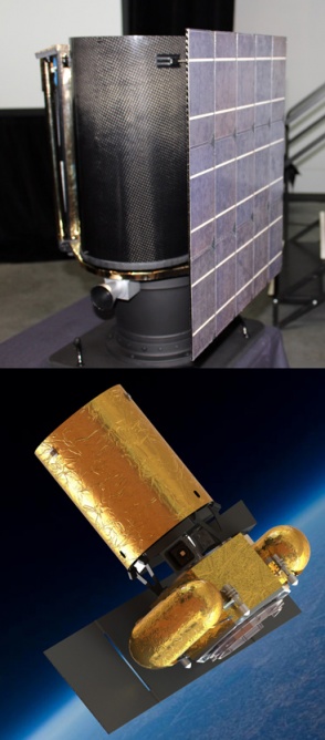
The Arkyd 102 telescope in person (top) and in mocked-up artwork from Planetary Resources (bottom)
Google Earth and commercial satellite imagery
Some of the space telescopes could sell or provide updated imaging to Google Earth.
The Google founders are backers of Planetary Resources.
Google Earth is a virtual globe, map and geographical information program that was originally called EarthViewer 3D, and was created by Keyhole, Inc, a Central Intelligence Agency (CIA) funded company acquired by Google in 2004 (see In-Q-Tel). It maps the Earth by the superimposition of images obtained from satellite imagery, aerial photography and GIS 3D globe. It was available under three different licenses, two currently: Google Earth, a free version with limited function; Google Earth Plus (discontinued), which included additional features; and Google Earth Pro ($399 per year), which is intended for commercial use.
Google Earth Global: Generally 15 meter resolution (some areas, such as Antarctica, are in extremely low resolution), but this depends on the quality of the satellite/aerial photograph uploaded. United States has 1 meter resolution and there are other high resolution areas.
Most land areas are covered in satellite imagery with a resolution of about 15 m per pixel. This base imagery is 30m multispectral Landsat which is pansharpened with the 15m [panchromatic] Landsat imagery. However, Google is actively replacing this base imagery with 2.5 meter SPOTImage imagery and several higher resolution datasets mentioned below. Some population centers are also covered by aircraft imagery (orthophotography) with several pixels per meter. Oceans are covered at a much lower resolution, as are a number of islandss.
Most of the international urban image dates are from 2004 and have not been updated. However, most US images are kept current.
Planetary Resources would be able to provide a lot more fairly good resolution and frequently updated satellite imagery. This could be advertising supported based on the traffic.
Planetary Resources will also be able to provide updated and fairly good resolution Google Moon, Google Space and eventually Google Asteroid.
Every Major Telescope Observatory and Major university Would want to get an Arkyd Telescope
Every major ground observation station and astronomy institution would want to get a Arkyd space telescope to enhance their ground observation. If the Arkyd scopes get into the sub-$2 million range they will sell hundreds to thousands of the telescopes.
The first two phases of Planetary Resources plans
1. Put up many small space telescopes without propulsion
2. Add small propulsion to escape earth orbit and intercept asteroids
All look very affordable and profitable for $10-50 million per year.
Piggy Back launches of 20 kg satellites will be far cheaper than buying whole rockets.
I think by 2017-2020 the space mining of Planetary Resources will be far more affordable than the prior studies of $2.6 billion to bring back 500 tons to high earth orbit.
Earth Imaging Market
In total, 111 satellites were launched for Earth Observation, excluding meteorology, between 2001 and 2010 from 26 countries, including commercial missions, compared with 251 satellites from 43 countries anticipated between 2011 and 2020. The abundance of EO satellites will vastly increase the supply of data available to applications, services, and scientific research and development. The focus of the satellite missions is determined by the typology of system operator.
Overall, investment into civil government Earth Observation reached $5.9 billion in 2010—an all-time high.
Sales of commercial data reached $1.3 billion in 2010 and continue to grow strongly. The U.S. government remains by far the largest consumer of commercial EO data, primarily for defense purposes through the National Geospatial-Intelligence Agency (NGA). Following consolidation in the U.S. industry, the industry has grown strongly—by a 23 percent compound annual growth rate during the last five years—largely in response to growing requirements for defense applications. Furthermore, the private sector is showing signs of increased development, particularly for location-based applications.
In total, 83 percent of all commercial data sales are from optical solutions. The remaining 17 percent come from synthetic aperture radar (SAR) data solutions. Somewhat unsurprisingly, sub-1-meter-resolution datasets represent the bulk of data sales, such as data provided by U.S.-based operators DigitalGlobe and GeoEye. Because the U.S. Department of Defense is the key customer for image intelligence applications, customers show a clear preference for high resolutions and higher accuracy data sources.
James Cameron is also a backer of Planetary Resources
There could also be interesting side business making documentaries using the abundance of space imagery and video.
If you liked this article, please give it a quick review on ycombinator or StumbleUpon. Thanks

Brian Wang is a Futurist Thought Leader and a popular Science blogger with 1 million readers per month. His blog Nextbigfuture.com is ranked #1 Science News Blog. It covers many disruptive technology and trends including Space, Robotics, Artificial Intelligence, Medicine, Anti-aging Biotechnology, and Nanotechnology.
Known for identifying cutting edge technologies, he is currently a Co-Founder of a startup and fundraiser for high potential early-stage companies. He is the Head of Research for Allocations for deep technology investments and an Angel Investor at Space Angels.
A frequent speaker at corporations, he has been a TEDx speaker, a Singularity University speaker and guest at numerous interviews for radio and podcasts. He is open to public speaking and advising engagements.