
Ad Support : Nano Technology Netbook Technology News Computer Software

* white roofs create an additional 20 percent energy savings by cutting cooling costs
* 360,000 square miles (less than 1 percent of the world’s land surface, 230 million acres) covered by urban rooftops and pavement were a white or light color, enough sunlight would be reflected back into space to delay climate change by about 11 years
* People in the shade in some sunny areas are 10 or more degrees cooler
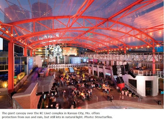
Creating awnings or special shade structures like the Kansas City Live! roof cover would provide the reflection over roads without causing glare for drivers. A more advanced version of this would use the structure as a platform for solar power and smart road enabling devices.
I have submitted this idea to the GE Ecomagination challenge. I will provide a link for readers to vote in support of this and other ideas in the Ecomagination challenge. Here is the link to vote for this idea at the GE ecomagination challenge.
I have followed up with a case for geodesic domes over communities.

The Kansas City Live! structure was made out of EFTE which can last for 50-200 years. It cost about $1.8 million and covers about 29,000 square feet or two thirds of an acre.
The EFTE weighs one hundred times less than glass and can be 24-70% of the cost.
Costs for awnings over roads, parking lots and buildings and dark areas could be reduced by using street lights and telephone polesas the anchor points to reduce costs.
There are more inexpensive forms of PVC and any large scale implementation could examine ways to reduce costs.
If another 230 million acres could be covered by awning at $1000 per acre in volume then $230 billion cost would be offset by carbon offset 25-31 gigatons and reduced heating costs ($735 million/year.
For the northern hemisphere summer, they found that increasing the reflectivity of roof and pavement materials in cities with a population greater than 1 million would achieve a one-time offset of 57 gigatons (1gigaton equals 1 billion metric tons) of CO2 emissions (31 Gt from roofs and 26 Gt from pavements). That’s double the worldwide CO2 emissions in 2006 of 28 gigatons.
Tensil fabric structures can span unsupported lengths of up to 150 feet and tensile steel cable nets with fabric can easily span twice that amount. Air structures can span even longer distances with column free structures up to thousands of feet.
Prevent Weather Related Accidents With Covered Roads
Here are the US statistics on weather related traffic accidents. The increased traffic accidents cost lives and vehicle damage and increased insurance costs. Also, accidents cause increased fuel usage by causing other cars to slow down and idle. It also costs society in terms of wasted time.
Covering the highways and high traffic roads would save billions each year in avoided accidents.
■On average, there are over 6,400,000 vehicle crashes each year. Twenty-four (24) percent of these crashes—approximately 1,561,000—are weather-related. Weather-related crashes are defined as those crashes that occur in adverse weather (i.e., rain, sleet, snow, and/or fog) or on slick pavement (i.e., wet pavement, snowy/slushy pavement, or icy pavement). Nearly 7,400 people are killed and over 673,000 people are injured in weather-related crashes each year. (Source: Eleven-year averages from 1995 to 2005 analyzed by Noblis, based on NHTSA data).
■Most weather-related crashes happen on wet pavement and during rainfall. Seventy-five (75) percent of weather-related crashes occur on wet pavement. Fortyseven (47) percent happen during rainfall. Fifteen (15) percent of weather-related crashes happen during snow or sleet. Thirteen (13) percent occur on icy pavement. Eleven (11) percent of weather-related crashes take place on snowy or slushy pavement. Only two (2) percent happen in the presence of fog. (Source: Eleven-year averages from 1995 to 2005 analyzed by Noblis, based on NHTSA data)
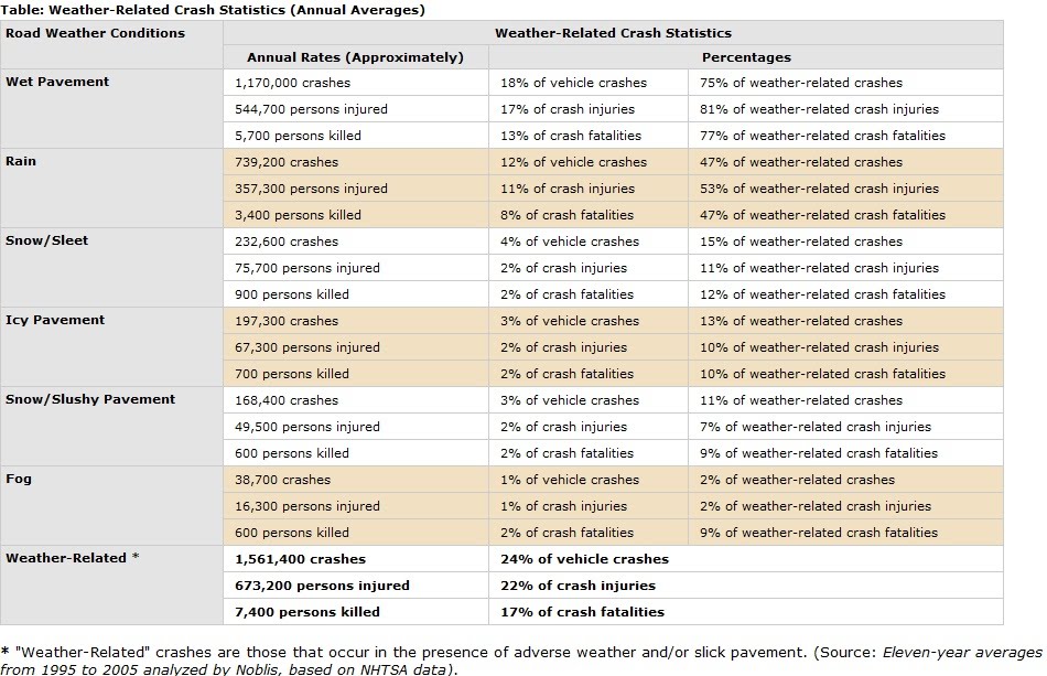
■Each year trucking companies or CVOs lose an estimated 32.6 billion vehicle hours due to weather-related congestion in 281 of the nation’s metropolitan areas. Nearly 12 percent of total estimated truck delay is due to weather in the 20 cities with the greatest volume of truck traffic. The estimated cost of weather-related delay to trucking companies ranges from 2.2 billion dollars to 3.5 billion dollars annually. (Source: ” Analysis of Weather Incident Effects on Commercial Vehicle Mobility in Large U.S. Cities,” Mitretek Systems).
Longest Covered Roads and Bridges
City street road covers can use existing buildings for support. Bridges can use bridge structures to enable road cover support. The priority for most valuable road covers would on high traffic roads and where there are more accidents and cities with more heat island effects.
This is roadway improvement that would be guaranteed to saved lives by reducing or eliminating weather effects. It would be infrastructure stimulus and could be mix of federal highway spending and city, state and regional spending. It would provide a boost to the depressed construction industry.
the numbers for the white roads came from the white roof/white roads studies Akbari presentation on cool roofs
Cool roof study at Lawrence Berkeley National Laboratory
Radiative forcing and temperature response to changes in urban albedos and associated CO2 offsets Lawrence Berkeley National Laboratory, Global Modeling and Assimilation Office
There is also the big effect of reducing weather related car accidents and traffic jams by 18%. weather related traffic jams also use more fuel. Probably could reduce the time lost to congestion by 5 billion hours per year. Saving billions of gallons of fuel. Saving thousands of lives and reducing injuries by 600,000 in the US alone. The stats are from the federal highway department.
Traffic Accident Google Map

If you liked this article, please give it a quick review on Reddit, or StumbleUpon. Thanks
Supporting Advertising
Business Success
How to Make Money
Executive Jobs
Paid Surveys
Thank You

Brian Wang is a Futurist Thought Leader and a popular Science blogger with 1 million readers per month. His blog Nextbigfuture.com is ranked #1 Science News Blog. It covers many disruptive technology and trends including Space, Robotics, Artificial Intelligence, Medicine, Anti-aging Biotechnology, and Nanotechnology.
Known for identifying cutting edge technologies, he is currently a Co-Founder of a startup and fundraiser for high potential early-stage companies. He is the Head of Research for Allocations for deep technology investments and an Angel Investor at Space Angels.
A frequent speaker at corporations, he has been a TEDx speaker, a Singularity University speaker and guest at numerous interviews for radio and podcasts. He is open to public speaking and advising engagements.